Landscan
-----------
Last updated on 7/28/2023 2:11:41 PM.
Landscan Overview
LandScan USA (known as LandScan) population is a nationally consistent raster dataset that depicts estimated residential (nighttime) population. The data are developed by fusing satellite remote sensing data, traditional geospatial infrastructure datasets, and US Bureau of Census demographic data. Each roughly 90m x 90m pixel has a nighttime population assigned to it. The population values are binned into 7 distinct classes for display. Pixels with no population are transparent. Population estimates reported in values inventories are the sum of the values of all pixels within the inventoried area (model output, planning area, wildfire polygon, etc).
Details
One of the significant limitations identified with census-based approaches to mapping human population occurs where non-developed land, including public lands, are included within a census block. This can result in large, sparsely settled areas showing relatively low population density across a large polygon- when in reality a small cluster of homes (small dense population) is surrounded by totally uninhabited lands.
To work around this limitation, LandScan uses “Intelligent” dasymetric modeling to refine the distribution of the population within each census block polygon (Bhaduri et al., 2007). Rather than evenly distributing the population throughout the census block,the LandScan algorithm divides each polygon into a 90-meter grid and distributes the total block population to the grid cells according to weights proportional to the calculated likelihood of being populated.
The likelihood of being populated is based on proximity to landmarks and geographic features such as roads and water bodies, as well as geologic features such as slope. Where available, structure location data was also incorporated into this methodology. These statistical models are further improved through analyst intervention to validate input data and parameters. The sum of the population of all cells within a census block is constrained to equal that of the census block in order to maintain the integrity of the census data.
While population is represented at the relatively high resolution of 90 meters/pixel, precision of the data does not support analysis at large scales, due to displacement between a given pixel and the structure/structures it represents. Thus, the data are appropriate for use at a strategic level, but not at a tactical level. To encourage use at the appropriate scale, these data are not displayed at scales zoomed in beyond 1:50,000.
Display in WFDSS
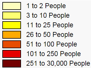
A nighttime population is assign to every ~90 meter pixel. The population value is used to bin the data into 7 distinct classes. Cells with a value of zero or “NO DATA” are displayed as transparent. The bin values are the same as those provided by Oak Ridge National Labs.
Figure 1: Landscan Legend
Update Cycle
LandScan USA data are a part of the Homeland Security Infrastructure Program, HSIP Gold data product, provided under an agreement with the Homeland Infrastructure Foundation-Level Data Working Group (HIFLD). Data will be refreshed as updated HSIP products are released. Generally, this frequency has been annual in nature.
Data Security
HSIP Gold is a unified homeland infrastructure geospatial data inventory assembled by NGA in partnership with the Department of Homeland Security (DHS) for official use by the Homeland Security and Homeland Defense (HLS/HD) communities. It is a compilation of over 560 geospatial datasets characterizing domestic infrastructure and boundaries assembled from a variety of Federal agencies, commercial vendors, and State mission partners. Our most recent version of HSIP, in its entirety, is unclassified; it is subject to the handling and distribution rules for "Unclassified For Official Use Only" due to licensing and sharing restrictions set forth by the data source entities.
For this reason, the data are not available for download within the WFDSS application or through the WFDSS data download page.
Relevant Websites and References
Homeland Infrastructure Foundation-Level Data Working Group located at https://hifld-geoplatform.opendata.arcgis.com/.
Data Information
Source: |
HSIP Gold data product |
Data Extent: |
National: Continental US, Alaska, Puerto Rico, and Hawaii |
Projection/Datum: |
GSC_WGS_1984 |
Data Access: |
References
Bhaduri, B., Bright, E., Coleman, P., & Urban, M. L. (2007). LandScan USA: A high-resolution geospatial and temporal modeling approach for population distribution and dynamics. GeoJournal, 69, 103–117
Haas, Jessica R.; Calkin, Dave E.; Thompson, Matthew P. (2013). A national approach for integrating wildfire simulation modeling into Wildland Urban Interface risk assessments within the United States. Landscape and Urban Planning, 119:44-53