Previous Topic

Next Topic

Book Contents

Book Index

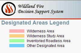
Accessing the Designated Areas Legend

To access the Designated Areas Legend, choose Intelligence > Map > Layers > Reference > Designated Areas Legend icon. The Designated Areas Legend appears.

Figure 1: Designated Areas Legend

Designated Areas Legend

-----------
Last updated on 9/28/2016 3:44:22 PM.

In This Section

Map Legends

See Also

Accessing the Administrative Boundaries Legend

Accessing the Arrival Time Legend

Accessing the 1 Hr Fuel Moisture Legend

Accessing the 10 Hr Fuel Moisture Legend

Accessing the Crown Fire Activity Legend

Estimated Ground Evacuation Time Legend

Accessing the Fireline Intensity Legend

Accessing the Fires 2010 Legend

Accessing the Flame Length Legend

Accessing the Heat per Unit Area Legend

Accessing the Incident Marker Legend

Accessing the Max Spread Direction Legend

Accessing the Rate of Spread Legend

Accessing the Solar Radiation Legend

Accessing the STFB Legend

Accessing the Wind Direction Legend

Accessing the Wind Speed Legend

Reference

Field Descriptions

Glossary Resources

Spatial Data Reference

Landscape Data Source Reference

Relative Risk Reference

Organization Assessment Reference

Fire Behavior Reference

About the WFDSS Decision Editors