The current size of an incident in acres. Acreage fields throughout WFDSS are updated automatically when the Incident Size field is changed on the information tab or updated by IRWIN.
-----------
Last updated on 5/22/2019 4:00:33 PM.
In WFDSS, an item is activated on the date that a decision including the item is published. The item is deactivated when a decision is published that specifically excludes the item.
These activation dates appear automatically when the decision is published, and affect the following items:
-----------
Last updated on 5/27/2011 12:42:55 PM.
The date fuel conditioning ends and wind speed and direction are retrieved for Basic and STFB models.
-----------
Last updated on 1/28/2019 12:09:08 PM.
A sequence of descriptive characters chosen to identify a particular analysis. For example, "14d 500f 0826p OakFlat" would identify a 14-day FSPro run that simulates 500 fires, uses a perimeter dated August 26 and uses the OakFlat RAWS for weather and wind data.
The analysis name cannot contain an apostrophe or backslash; the cursor blinks if you try to add these characters and a message displays that these characters are disabled. Underscores and other punctuation are not recommended and an analysis name can be changed any time before an analysis is submitted.
Descriptive names become important when multiple analyses exist for an incident and are limited to 48 characters.
-----------
Last updated on 8/27/2019 10:55:20 AM.
The date specified for an FSPro analysis to begin.
-----------
Last updated on 4/7/2011 1:46:07 PM.
The date fuel conditioning ends and wind speed and direction are retrieved for Basic and STFB models.
-----------
Last updated on 8/25/2010 4:18:26 PM.
Burn period refers to the time of a fire's active burning (hours or minutes depending on application).
-----------
Last updated on 8/25/2010 4:20:21 PM.
The time fuel conditioning ends and wind speed and direction are retrieved for Basic and STFB models. This field is unique to Basic and STFB because these models do not truly have an 'Analysis Start Time'. Mid-afternoon times are often chosen to represent a worst case for burns that 'start' in the early afternoon. Both models assume static weather conditions and, therefore, the total hours burned can be broken up any number of ways to match conditions.
-----------
Last updated on 8/25/2010 4:23:28 PM.
The year the fire start occurred and one of three fields that comprises the unique fire identifier. A calendar year begins on January 1 and ends on December 31.
-----------
Last updated on 8/25/2010 4:29:41 PM.
The number of days prior to the start date that fire behavior models will adjust dead fuel moistures to reflect the influences of local site conditions. See also fuel moisture conditioning.
-----------
Last updated on 3/2/2012 10:57:39 AM.
See NWCG definition: NWCG Wildland Fire Glossary.
-----------
Last updated on 8/4/2010 5:47:17 PM.
See NWCG definition: NWCG Wildland Fire Glossary.
-----------
Last updated on 8/4/2010 5:50:39 PM.
One of the outputs calculated by WFDSS BFB. The output indicates the type of fire calculated at any given cell and is displayed as 1 (surface fire), 2 (passive crown fire/torching), 3 (active crown fire) and 0 (no fire).
Since WFDSS BFB calculates fire behavior characteristics cell by cell, the crown fire activity of any cell is independent of any adjacent cells. This means active crown fire cannot "spread" cell to cell.
-----------
Last updated on 7/28/2010 3:40:32 PM.
Select one of two the methods available that model crown fire: Finney (the default) or Scott and Reinhardt.
For recent versions of LANDFIRE (2010, 2014) canopy fuel values for CBD were computed to produce more active crown fire when using the Scott and Reinhardt model compared to the Finney crown fire model. You would expect to see slower rates of spread and less fire intensity for predicted passive crown fire when using Finney versus Scott and Reinhardt crown fire models. Whatever crown fire model is chosen, it is important to calibrate your simulated fire behavior to observed fire behavior.
-----------
Last updated on 8/3/2018 10:41:31 AM.
Provides information about the decision, such as date published, estimated cost, incident owners and editors, reviewers, and approvers. A brief decision history shows which team members participated in developing the decision document.
This summary appears automatically when a decision is published.
-----------
Last updated on 7/28/2010 2:29:55 PM.
The date when a fire is discovered.
-----------
Last updated on 7/28/2010 1:31:24 PM.
HH:MM that a fire was ignited or estimated to have ignited.
-----------
Last updated on 7/28/2010 3:41:49 PM.
The date specified for an NTFB analysis run to finish.
-----------
Last updated on 8/25/2010 4:25:15 PM.
The hour specified for an NTFB burn period to finish.
-----------
Last updated on 8/25/2010 4:25:57 PM.
Number of acres burned, including unburned and unburnable islands, within a final fire perimeter of a specific, individual incident at the time a fire is declared out.
-----------
Last updated on 7/28/2010 1:45:14 PM.
Once an incident is created in WFDSS, the Author of the incident can request fire behavior analyses that include Basic, Short-Term, and Near-Term Fire Behavior, as well as FSPro.
-----------
Last updated on 1/28/2019 2:07:38 PM.
A four-character code used to track and compile cost information for a particular wildfire emergency suppression incident. The purpose of the FireCode is to provide a common code for each large wildfire to be used in the accounting code structure of all federal wildland fire agencies. (NWCG Data Standards)
-----------
Last updated on 12/8/2010 5:49:47 PM.
The distance from the ground at the leading edge of the flame to the tip of the flame. It is one of the outputs calculated by the fire behavior models. In WFDSS, Flame Length units are displayed in the analysis legend as meters.
-----------
Last updated on 7/28/2010 4:05:07 PM.
The moisture content of overstory conifer needles, a factor affecting crown fire initiation in fire modeling systems. Default value is 100%. It can be modified in BFB, STFB, and NTFB, but not in FSPro. Foliar moisture content is used in conjunction with canopy base height from the landscape extent to determine the threshold for surface to crown fire transition in each cell. It is not used to calculate crown fire rate of spread or to determine the difference between predicted passive versus active crown fire. Foliar moisture can be set from 70-130% and is constant across the landscape for the duration of a simulation; it is not conditioned over time or space. The foliar moisture value generally needs to be changed only if local sampling suggests that the actual value is extremely high or low, or when crown fire behavior appears misrepresented in the outputs.
-----------
Last updated on 11/15/2010 3:11:31 PM.
A boundary designated by governmental agencies (wildland fire protection agencies) within which they work together for the interagency, intergovernmental planning, coordination, and operations leadership for the effective utilization of emergency management resources within their area.
WFDSS uses the following 10 geographic areas as defined by the National Interagency Coordination Center (see map at https://www.nifc.gov/nicc/):
-----------
Last updated on 4/25/2023 3:43:16 PM.
The original WFDSS user who accepted ownership of an incident becomes the group owner when the individual creates a group of users with WFDSS Author role privileges and then transfers incident ownership to the group.
-----------
Last updated on 7/28/2010 2:30:16 PM.
The shapefile used as an analysis ignition for an FSPro or NTFB fire behavior analysis. One ignition file must be selected for an analysis but it can have multiple ignitions within it.
-----------
Last updated on 8/4/2011 4:58:12 PM.
The descriptve name given to the image being uploaded into WFDSS.
-----------
Last updated on 9/14/2010 1:34:48 AM.
Create a unique ID for the incident that is a minimum of two characters and does not exceed 50 characters. Each geographic area and unit may have its own naming conventions, so refer to those guidelines.
-----------
Last updated on 1/21/2014 11:58:43 AM.
Current size of an incident in acres. This field can be updated automatically via IRWIN, or updated manually in WFDSS.
-----------
Last updated on 5/21/2019 3:54:56 PM.
The source of the data used to:
You can override the default landscape data source for an incident by changing it on the incident's information page. A Fire Behavior Analyst can choose a data source appropriate for fire behavior analysis regardless of the default data source chosen for the incident.
Some landscape data sources contain nationwide data and others are specific to the locale, state, or region. View the Landscape Source data layer to ensure that the selected source is appropriate for the area of your incident.
A landscape file is composed of the following required data layers:
-----------
Last updated on 2/27/2013 2:34:16 PM.
A GIS Raster file that provides landscape themes such as elevation, slope, aspect, and fuel model that are used in fire modeling and mapping. The file structure began in the FARSITE/FlamMap fire analysis model, but is currently available nationally from LANDFIRE, a nationwide fire, fuel and vegetation mapping project. (Paraphrased from Guidance on Spatial Wildland Fire Analysis: Models, Tools, and Techniques by Richard D. Stratton.)
The LCP used in WFDSS contains all of the rasterized data themes (elevation, slope, aspect, surface fuel model, canopy cover, forest stand height, canopy base height, and canopy bulk density) needed to run geospatial fire behavior applications.
-----------
Last updated on 7/28/2010 4:44:47 PM.
The angular distance north or south of the earth's equator, expressed in degrees along a meridian. Valid latitudes in WFDSS range from about N24-N49 for the lower 48 states, N51-72 for Alaska, and N18-N22 for Hawaii.
-----------
Last updated on 7/28/2010 4:52:44 PM.
See Local Number.
-----------
Last updated on 9/14/2010 1:37:28 AM.
A 4-6 digit number assigned to a fire by the reporting unit, and one of three parts that comprises the Unique Fire Identifier.The intent of the Local Number, or Local Incident Identifier as it's called in the NWCG Data Standards, helps to ensure each reporting unit has a scheme for uniquely identifying its individual fires for a given calendar year.
-----------
Last updated on 8/25/2010 4:56:15 PM.
The angular distance, expressed in degrees, minutes, and seconds of a point on the earth’s surface east or west of a prime meridian (usually the Greenwich Meridian). All lines of longitude are great circles that intersect the equator and pass through the North and South poles. (GSTOP) For the US, valid longitudes range from about W67-W126 for the lower 48 states, W153-W160 for Hawaii, and W130-E172 for Alaska.
-----------
Last updated on 7/28/2010 5:07:55 PM.
Maximum Spread Direction is one of the outputs calculated by WFDSS Basic Fire Behavior (BFB). Its units are displaymed in the BFB legend as Radians.
-----------
Last updated on 7/28/2010 2:01:34 PM.
The sum total of burn periods that are desired for a fire behavior analysis. More than one burn period can be used per day.
-----------
Last updated on 8/25/2010 4:57:43 PM.
The sum total of burn periods that are desired for a fire behavior analysis. More than one burn period can be used per day.
-----------
Last updated on 8/25/2010 4:58:17 PM.
Refers to how many fire simulations you would like FSPro to run in a single analysis. The number should be large enough to account for rare events that could impact fire growth and burn probabilities as influenced by the landscape extent and landscape raster resolution.
Experience over the last several years has indicated that, to account for the rare events in a simulation, a minimum of 1000 simulated fires is required. The only time fewer than 1000 fires should be considered is during the initial testing and calibration for an incident.
Larger numbers of fire simulations (>1000) process much more slowly, so take care in selecting the number. Base your decision on time of year, analyses currently queued and in process, and priority of the fire.
-----------
Last updated on 11/8/2011 3:40:40 PM.
The day it's decided that documentation for an incident is complete, all fields are up to date (including final fire size) and periodic assessments are no longer needed. Entering a date in this field will lock an incident permanently in WFDSS and edits are no longer possible.
-----------
Last updated on 8/4/2010 5:59:01 PM.
The name of the WFDSS user who accepted ownership of an incident. This person is then responsible for ensuring that a timely decision is created, reviewed and approved for an incident in WFDSS.
The Owner can perform the following tasks for incidents they own:
In addition, owners can create a Group and transfer ownership of the incident to that group. The members of the group then become joint incident owners. (See Group Owner.)
For more information on incident owners, see also the incident owner role description.)
-----------
Last updated on 7/28/2010 2:31:10 PM.
Required by an Incident Approver every 1-14 days to validate the current course of action and to determine if the current decision is still valid.
-----------
Last updated on 9/14/2010 1:35:18 AM.
See Unit ID.
-----------
Last updated on 8/25/2010 5:04:20 PM.
The day data was collected to create a shapefile. This date is especially important for time-stamping all fire perimeters and analysis ignitions.
See also Shape Label, Shape Type.
-----------
Last updated on 7/28/2010 1:13:53 PM.
A name that describes the polygon(s) contained in the shapefile to be uploaded. This name appears on the map displays and is limited to 50 characters.
See also Shape Type, Shape Date.
-----------
Last updated on 5/31/2010 2:01:07 PM.
The kind of polygon being uploaded or created. Shapefiles must contain polygons and can represent fire perimeters, analysis ignitions, barriers, landscape masks, mgmt action points or final fire perimeters. WFDSS uses each of these types in different ways in the system, so it's important to distinguish the purpose of the polygon.
See also Shape Label, Shape Date
-----------
Last updated on 5/31/2010 2:01:16 PM.
Source Types refers to how the shape files were derived. There are 8 source types.
Estimate of the amount of time (in minutes) that passes between an ember landing and fire spread occuring. Default is zero minutes.
-----------
Last updated on 7/28/2010 1:31:34 PM.
A decimal value that estimates the likelihood of a lofting ember landing on a receptive fuel bed. Initial runs should be done with no (or limited) spotting to calibrate, as higher values may slow the model run time considerably. The spotting probability value range differs between models.
-----------
Last updated on 5/21/2019 1:55:23 PM.
A number (integer from 0-999999) that is used in randomly generating spot fire occurrence and locations. This number generates automatically for newly created analyses. There is generally no need for users to change this value. When an analysis is copied, the Spotting Seed is copied along with other settings. Two analyses with the same settings (including Spotting Seed) should generate the same spotting results.
The date specified for a NTFB fire behavior analysis to begin.
-----------
Last updated on 8/12/2010 9:54:35 AM.
The hour specified for an NTFB burn period to begin.
-----------
Last updated on 8/25/2010 3:28:10 PM.
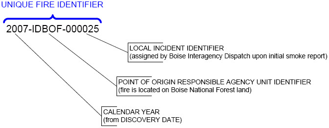
A unique identifier assigned to each wildland fire. (NWCG Data Standards)
The unique fire identifier is composed of three parts, delineated in the image below. In WFDSS, each part is a field that requires inputs on the incident information page. Local Number corresponds to Local Incident identifier, Unit ID corresponds to Point of Origin Responsible Agency Unit Identifier, and Calender Year is the same.
-----------
Last updated on 12/23/2021 4:19:28 PM.
A code used within the interagency wildland fire community to uniquely identify a particular organizational unit within the government or a non-government organization recognized by NWCG as a wildland fire cooperator. The NWCG Data Standards use the term Point of Origin Responsible Agency Unit Identifier, but the field has been shortened to Unit ID on the WFDSS incident information page. It is one of three parts that comprises the Unique Fire Identifier.
-----------
Last updated on 8/25/2010 5:16:23 PM.
The name of the agency unit (e.g., Gila National Forest) whose fire and land management plans inform decision-making for an incident in WFDSS.
-----------
Last updated on 2/5/2010 12:32:17 AM.