Monitoring Trends in Burn Severity (MTBS)
-----------
Last updated on 7/28/2023 2:13:28 PM.
Overview
Monitoring Trends in Burn Severity (MTBS) is a multi-year project designed to consistently map the burn severity and perimeters of fires across all lands of the United States from 1984 to present. MTBS uses the USGS Landsat image archive to provide a consistent and continuous source of 30 meter resolution data for mapping burn severity of all fires greater than 1000 acres in the west and 500 acres in the east.
NOTE: The MTBS displayed update schedule usually runs a year or two behind the present date.
- More about MTBS: http://mtbs.gov/mapping-methods.html
Display in WFDSS
MTBS data for the continental United States (CONUS) are separated into layers by year, with a toggle “check box” that can turn on any single year’s data. For a single year, burn area boundaries as mapped by MTBS are displayed as a red outline. Burn severities within each burn area boundary are shown as a categorized image (thematic raster) color-coded according to burn severity:
Figure 1: Burn Severities
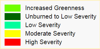
Color-coded burn severities, with dark green representing the “Unburned to Low” severity category, cyan as “Low” severity, yellow as “Moderate” severity, red as “High” severity, light green as “Increased Greeness”, and white as non-processed areas.
Due to the nature of the data as imagery rather than polygon features, it is not possible to select and copy a specific category to create a mask. Instead, the data can be used as a background upon which a mask can be drawn.
Data for each calendar year are displayed as layer in the WFDSS layer-switcher tree. Each year can be turned on or off individually by clicking its corresponding check-box. The last ten years of data are displayed at the top of the tree, and the older data (dating back to 1984) are displayed under the heading “Older”.
Figure 2: MTBS Layer

Update Cycle
MTBS data are delivered to WFDSS as a “Web Mapping Service” directly from the MTBS program, and as such, new data will be available in WFDSS as it is updated by MTBS. MTBS updates the web service as fires are processed, and data (including the addition of prior year data in response to user requests) are added to the service throughout the year. Announcements of new data are provided on the MTBS Announcements webpage.
Datat Information
Table 1: Data Information
Information |
Description |
Source |
Web Service provided by USDA Forest Service Remote Sensing Applications Center (RSAC) located in Salt Lake City, UT, USA |
Extent |
Continental US |
Projection/Datum |
Web Mercator (EPSG: 3857) |
Data Access |
GIS Team Contacts
The WFDSS application is "data rich". It requires data which is spatially oriented and graphically displays information to support wildland fire and other natural resource decisions. Due to the type and number of interagency spatial data sets required in April 2009 an interagency GIS Team was formed to provide data support for WFDSS. This Team is responsible for acquiring, consolidating, and validating their agency spatial and tabular data. In addition this team developed and maintained communications among local, regional, and national agency personnel to improve the collection process and provide explicit guidance on data needs. The members of the WFDSS GIS Team are:
Table 1: WFDSS GIS Team Contacts
|
||
WFMRD&AAmanda Rumsey |
WFMRD&AJonah Vaughan |
WFMRD&ASusan McClendon |
BLM - AFSJennifer L. Jenkins |
BLM - NIFCJulie Osterkamp |
BIA - NIFCJoseph Kafka |
NPS - NIFCSkip Edel |
USFS - NIFCCole Belongie |
USFWS - NIFCAndrew Bailey |