|
|
|
|
|
About Planning Areas
A Planning Area is an area an Incident Owner or Editor defines on the landscape that includes all the land a fire might burn during the life of the current decision; it includes the area used for analysis and planning to manage the fire. Planning Areas establish an area of interest around an incident and accomplish two things:
- They determine which FMUs/SOs are contained or partially contained by the planning area, and subsequently, which pre-loaded Strategic Objectives and Management Requirements will need to be addressed when developing Incident Objectives and Requirements, and
- They generate a Values Inventory, a list of known values that are located in the planning area. These values should be considered and/or addressed when developing a relative risk assessment and Incident Objectives.
Planning areas are required for documenting a decision and are different from a WFSA boundary or WFIP Maximum Manageable Area, two outdated and no longer used concepts. By limiting the planning area to just where you think a fire might go, you are limiting the decision support capability of the application.
Planning Areas and Jurisdicational Agencies
When you draw a planning area, the jurisdictions it intersects updates on the Incident Information tab and in the Incident History. When you shrink your planning area, the Incident History does not automatically remove the agencies no longer covered in the planning area. You must manually remove these agencies from the Information screen. To add one or more jurisdiction(s), manually add them on the Incident Information screen. Changes to the jurisdictional agencies can be tracked by viewing the Incident History.
How large should a planning area be?
Planning areas need to be large enough to include:
- Where actions are planned (e.g., firelines, evacuation points, protection points.)
- Contingency plans (MAPs.)
- Fire behavior modeling outputs.
- Values you are concerned about.
- Where you want to contain the fire.
- The physical reality of where the fire could burn during the life of the current decision (even if you don’t want it to burn there.)
Drawing a large planning area may incorporate more FMUs or Strategic Objectives, which in turn may require you to address more Strategic Objectives, Management Requirements, and values at risk, but if your Planning Area is too small, you will have to create a new decision each time management actions occur outside of it. It's helpful to use an FSPro long term probability output as a general guide when trying to determine an appropriate Planning Area size; the outputs can help inform you of where the fire may try to move as well. Doing this ensures that the Values at Risk identified by an FSPro output are included in the Values Inventory (a product of the planning area), and addressed in the Incident Objectives or Incident Requirements and subsequently through the Course of Action. If your FSPro outputs are larger than your Planning Area, your Planning Area is likely too small.
No ramifications result from drawing a large Planning Area. If you are currently developing Management Action Points or contingency actions outside of your Planning Area, it should be larger to include those areas.
Who is Involved in the Creation of a Planning Area?
When developing an appropriate planning area for an incident, it is important to include input from various fire managers, agency administrators, and potential resource specialists or other staff. Proper sizing of a planning area is important to identify the area of potential incident impact. Local Fire Managers (i.e. Incident I.C., Incident Operations, and Duty Officer) can help identify the area of expected actions, Management Action Point (M.A.P.s), and containment boundaries. In the absence of local guidance, fire behavior modeling outputs can also help inform the creation of a realistic planning area.
Planning Area Examples
The following examples represent things to consider when drawing a planning area:
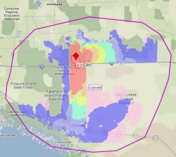
Table 1: Example of Proper Planning Area
The planning area to the right is large enough to contain FSPro modeling outputs and is sufficient in size. The planning area is not the same as a WFSA boundary or a Maximum Manageable Area from a WFIP. It is a planning analysis area. It is not necessarily where you want fire on the landscape, but where the fire may want to move no matter what resources we throw at it. |
|
Tables 2, 3, and 4: Improper Planning Areas
Table 2: Example of Improper Planning Area
This planning area is too small. The idea of WFDSS is to plan ahead—it’s a proactive tool rather than a reactive tool. By limiting the planning area to just where you think the fire might go, you are limiting the decision capability of the application. You are also creating more work for yourself because a new decision will be needed each time the fire burns outside the planning area. |
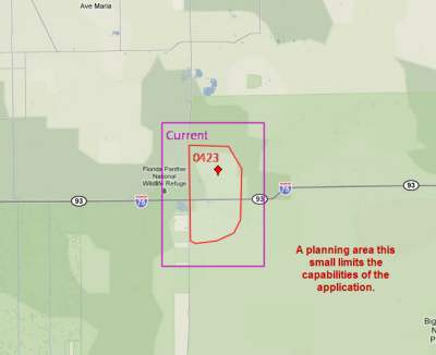
Table 3: Example of Improper Planning Area
This planning area uses tactical lines such as roads, ridgetops or drainages, which is not how planning areas are designed to be used. A new decision is needed each time the fire crosses one of these features. These types of features are best used as Management Action Points (MAPs) within a large planning area. Each time the fire thresholds and the decision is still current. |
|
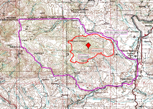
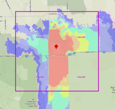
Table 4: Example of Improper Planning Area
This planning area is too small because the FSPro outputs are much larger than the planning area. The Values are Risk, a list of values generated by an FSPro run, identifies known values that are located within the model outputs. When your FSPro outputs are larger than your planning area, values identified as ‘at risk’ may not be included in the planning area and ultimately, not addressed in the Incident Objectives and requirements. |
|
WFDSS user roles (Viewer, Dispatcher, Author, GA Editor, National Editor, and Data Manager) can optionally subscribe to planning area notifications for one or more units. When you draw a planning area and create a pending (but not published) decision, WFDSS users who have subscribed to planning area notifications are notified. These individuals received emails for each unit(s) they subscribed to, and were included in the planning area when it was drawn.
For more information about planning areas, see:
- Lesson 8 - Situation Assessment and Map Images
- Creating a Planning Area
-----------
Last updated on 7/9/2020 10:43:16 AM.
In This Section |
See Also |
Reference |