|
|
|
|
|
About Analysis Shape Files (STFB, NTFB, FSPro)
Analysis Shape Files are the shapes used by the fire behavior analysis models to grow or limit fire spread. It is also a section found on the Model Information page within the STFB, NTFB or FSPro fire behavior models. Landscape Masks are also analysis shapes but are applied to an analysis when creating a landscape editor rule.
Figure 1: The Analysis Shapes Files Dialog Box
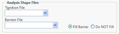
Fire Behavior Specialists can select an Ignition File and/or a Barrier File for an STFB, NTFB, or FSPro analysis from the:
However, the Model Information Menu Option is the only location where analyst can choose to fill a barrier.
Landscape masks are another type of Analysis Shape File, but these are only applied when using the Landscape Editor.
Note: For each fire behavior analysis, you can select only one Ignition File and/or one Barrier File. For example, when you select the Ignition File and/or Barrier File from the Model Information Menu Option and then select another Ignition File and/or Barrier File from the Analysis Map for the same fire behavior analysis, the file(s) selected in the Analysis Map will override selections made in the Model Information Menu Option. These options provide flexibility for analysts to develop a workflow that works best for them when developing an analysis.
-----------
Last updated on 1/29/2019 4:23:16 PM.
In This Section |
See Also |
Reference |